

April 15th, 2025
Pt. 2 of the Wildfire Series
The Camp Fire
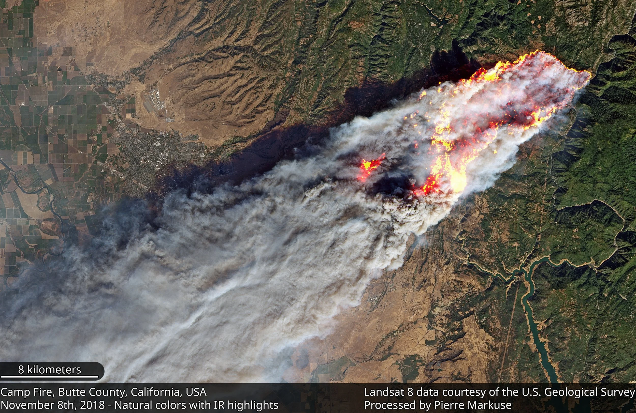
The Camp Fire was ignited by “a poorly maintained Pacific Gas and Electric Company (PG&E) transmission line” near Pulga, CA.
This article is intended to give a specific example of how a wildfire might unfold along the Evergreen SH-74 valley corridor, as it might for any community immediately surrounded by mountain terrain.
Leadup
In the years before California’s most recent drought broke, the region was beginning to be plagued by constant fires, some extremely large. In particular - the Camp Fire (2018) - began north of Paradise, CA, and rapidly spread south-west through a number of small towns lying in a valley between two waterways, West Branch Feather River to the East and Butte Creek to the West. Both rivers are in steep ravines, largely confining the town’s emergency evacuation routes to the SW. Essentially the evacuees where trapped by the terrain and chased by the fire, with no lateral escape.
The cause -
“part of a poorly maintained Pacific Gas and Electric Company (PG&E) transmission line in the Feather River Canyon failed during strong katabatic winds. Those winds rapidly drove the Camp Fire through the communities of Concow, Magalia, Butte Creek Canyon, and the Town of Paradise, largely destroying them.” - Wikipedia
Not dissimilar to one of the two ignition sources of the Colorado Marshall Fire.
Katabatic Winds
“a strong downslope windstorm”
The Camp Fire was, considering its semi-rural setting, one of the most destructive and deadliest fires in the history of the United States. This was certainly exacerbated in a large part because homes and businesses were embedded and interspersed within forestland, creating a broad and sometimes uninterrupted canopy for the inferno to rage across.
“When faced with a fire burning a “football field every second”, and high winds carrying ash and embers in front, it only took 4 hours for most of the destruction to take place.“ - NYT
Other factors contributing to the rate and intensity of burn: wind speed and direction, low humidity, a variety of fuel types and their volume/density.
The emanated heat prepared the fuel for ignition by rapidly drying out any remaining moisture, particularly from coniferous trees. Wildfires can create their own weather system, such as their own winds.
The Camp Fire demonstrates that high winds can not only drive a fire rapidly but also make it '“jump over” and trap evacuees. Mountain terrain channels people and animals but also directs winds that flow downhill (as with katabatic and fohn/Chinook winds). Lateral escape can be reduced to a few narrow routes, or none at all. Opposed to a conventional landscape where the roads are straight, flat, and with more egress options (urban street grids, open land), the roads in high country can force evacuees into a crush, backing up traffic for miles.
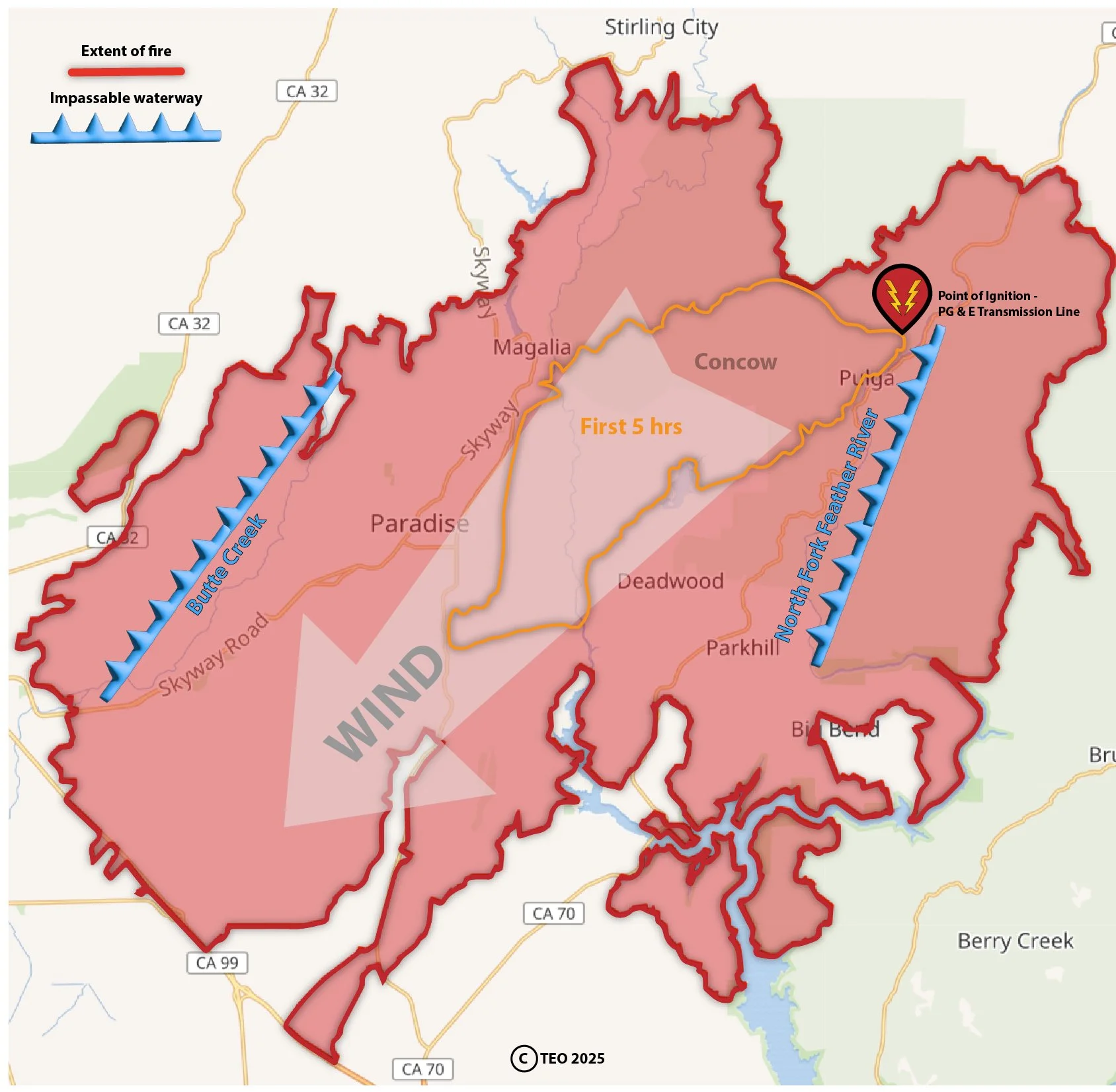
The bulk of the property destruction occurred in under 5 hours, an area roughly equal to Evergreen’s valley corridor along SH-74 from I-70/El Rancho to just south of the lake.
During and Aftermath
Although the Camp Fire burned for several days before it was contained, the bulk of the property destruction occurred in under 5 hours, an area larger than Evergreen’s valley corridor from I-70 to south past the lake (8 miles x 2 miles wide).
The average linear speed of the fire was approximately 2.2 mph, but much faster at some points, with embers igniting fuel hundreds of yards in front of the line. In this way lines of fire can move up 15 miles per hour, and in any direction. Ordinary people can’t run that fast in a sprint let alone sustain the pace.
“Skyway — a four-lane arterial that links the high pine country of the foothills and the valley cities like Chico — is a blessing to commuters and day-trippers. But on this day it becomes a place of desperation where people are stuck, creeping through gridlock as the flames close in.” - NYT
“The town’s main thoroughfares had recently been “road dieted” from four lanes to two, trapping more cars in traffic as flames overtook them, resulting in at least 7 deaths.” - LaTimes
“The creeping, harrowing trip out in two vehicles takes four hours.” - NYT
“It was hell on earth getting out of there,” Mr. Raulerson said. “If we’d stayed 10 minutes longer we would have been burned.” - NYT
Even a four-lane highway is no guarantee of escape, and Skyway does not dwindle down to two lanes going south, as is the case with Evergreen’s stretch of SH-74 as it approaches the lake in the same direction as downslope winds blow.
“The Camp Fire caused 85 civilian fatalities, and injured 12 civilians and five firefighters.” - Wikipedia
“As of the 2020 census, the [Paradise] town population was 4,764, down from the 26,218 recorded in the 2010 census.”
Current population estimate is 9,000, very close to what Evergreen’s is currently.
“The fire ultimately burned a total area of 153,336 acres” (240 sq mi) - Wikipedia
“As the Camp Fire spread throughout Paradise and the surrounding towns, engulfing homes and schools, officials did not send Wireless Emergency Alerts, or WEAs: Amber Alert-style evacuation notices to all area cell phones. But even if they had, many of the area’s older residents used landlines, and cell service in Paradise was spotty.” - SFGATE
The list of victims from the Camp Fire. Many were either disabled or older, or both, and died in or near their homes. One victim could not escape -
“because the power was out she couldn’t get her car out of the garage” and “she could not reach the manual release for the garage door, and even if she could, she was not strong enough to raise the door.”
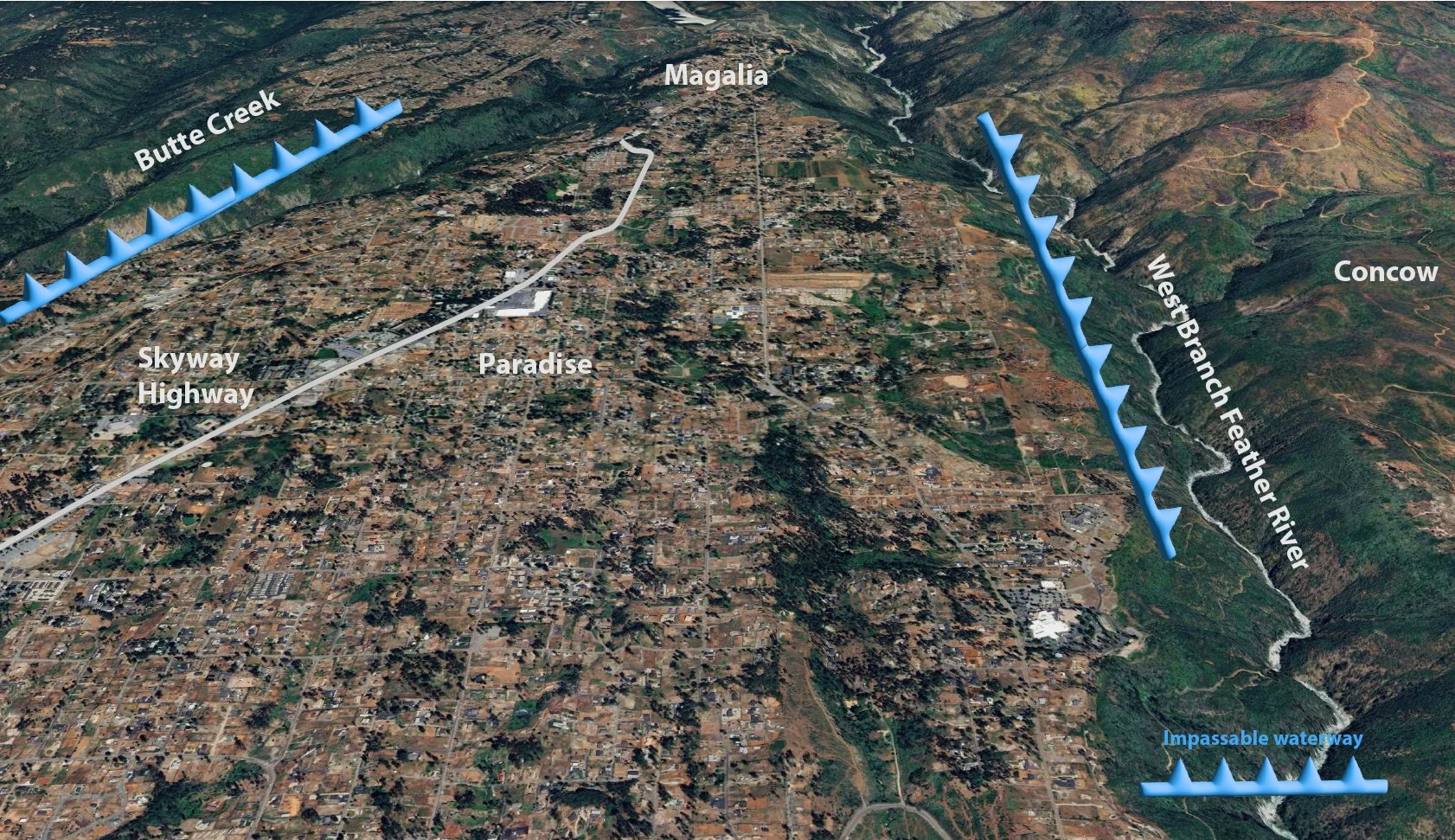
For Paradise and Magalia, lateral escape was blocked by steep waterways and mountains on both sides.
Common Denominators
What does Evergreen have in common with the topography of the Camp Fire? Downslope winds. Narrow escape routes and few of them. Choke points. A major route that bottle-necks going south. Truncated side roads. Forrest-embedded suburban homes. All surrounded by steep mountainous terrain.
“Pine trees are the most a highly flammable tree species due to their high density of resin glands. These resin glands release volatile oils and resins” - Quora
To give some perspective, the boundary of Evergreen as defined by EPRD (Evergreen Parks and Recreation District) is only 78 sq miles (or 1/3 the size of the Camp Fire burn area). The valley defined as the SH-74 from I-70 south to Evergreen Lake corridor is approximately 20 sq. miles.
An acronym commonly used among firefighters is WUI (Wildland-Urban Interface), which denotes when open space/wildland butts up or overlaps suburban development. In the case of Evergreen, we are also largely embedded.
The fact that EFR (Evergreen Fire Rescue) as yet does not have a fully formed evacuation plan may be an indication of how difficult the problem is to address. Certainly, many mountain communities have the same issues – narrow channels, downslope winds, high volume fuels. It may be that those truncated roads need to be prepared for evacuation traffic. But that probably requires some private property owners to agree or even be forced to accept conditional trespass for the community’s greater good. There is a precedent for this in at least one instance.
EFR Evacuation Plan - As of April 14th, 2025, there is no publicly available evacuation plan per Evergreen Fire Rescue. This does not imply they or JCSO are unprepared.
“Evacuation routes for the Evergreen Fire Protection District are currently under construction. Check back for updated maps. Until then, sign up for emergency notifications by clicking here.“
All photos/graphics TEO ©